


Punt was in the Americas is a necessary blog post to further demonstrate that America is the True Old World and the Biblical Holy Land. Punt is the Land of God that was located in the land of Kush (Ethiopia).


“The Land of Punt (Egyptian: pwnt; alternate Egyptological readings Pwene(t)[1] /pu:nt/) was an ancient kingdom known from Ancient Egyptian trade records. It produced and exported gold, aromatic resins, blackwood, ebony, ivory and wild animals.[2] It is possible that it corresponds to Opone in Somalia, as later known by the ancient Greeks,[3][4][5] While some biblical scholars have identified Punt or the Land of Punt with the biblical land of Put or Havilah.[6][7]“
“At times Punt is referred to as Ta netjer (tꜣ nṯr), the “Land of the God”.[8] Historians debate the exact location of Punt. Various locations have been offered, southeast of Egypt, a Red Sea coastal region: Somaliland, Somalia, Djibouti, northeast Ethiopia, Eritrea, and north-east Sudan. It is also possible that it covered both the Horn of Africa and Southern Arabia.[9][10][11] Puntland, the Somali administrative region at the end of the Horn of Africa is named in reference to it.[12]“
Punt is of course, the Biblical land (Holy land) and the birthplace of Ethiopia and Egypt. Punt is allegedly located in the Horn of Africa Punt and was also called the Land of the God, so knowing the original location of the land of God (Punt) is significant.
The Superior Land of Punt in the Americas:
I will demonstrate that the Americas is the superior Land of Punt with more places in the Americas that bear the name Punt. Plus, I will do this by demonstrating that the Americas is also the Superior Ethiopia (Abyssinia), since Punt and Ethiopia is like one and the same. Ethiopia is of course, associated with the Garden of Eden and the Fountain of Youth.
Punta Tetuan in North Mexico bears the same place name as Tetuan Morocco, in North Africa, which are both port cities. Morocco also means the land of God is located near Jerusalem on maps, as I have demonstrated in volume II of this book series and I will demonstrate again later. Punta Tetuan is the original Moroccan port city since Punta is just a Latinized version of Punt, aka, the land of Punt, which is Biblical. Plus, we know that vowels were sacred in ancient languages and were sometimes omitted, therefore, Punta is Punt if we omit the letter “A” at the end of the word Punta.
Since Punta or Punt is Biblical it predates the Tetuan, Morocco in North Africa, especially since the Holy Land and the old world is in the Eastern hemisphere of the world according to scholars and theologians (see post image of original compass showing the Americas as the East). Punta Tetuan is the original port city of Morocco because it is older, since the East is the old world and the land of the Bible.
Lower Punt and Central Punt:
Punta Tetuan was the central or middle Punt since the corresponding upper Punt was in South America. But where is Lower Punt? Lower Punt was obvious in North America, but where? Florida or La floridas was lower Punt since we have a Punta Gorda, Florida, which is also a coastal city. Plus, there is a Florida Map of the Original Garden of Eden designating Florida as Ethiopia and Assyria. The Garden of Eden is said to be in Ethiopia. Well, this Map of the Original Garden if Eden confirms it as factual (see post image).
In this post is embedded a YouTube video from the channel Old World Florida that features Dr. E.E. Callaway, called, “Florida is the True Garden of Eden”: https://www.youtube.com/watch?v=GbHv7tormnM .
We also have a Punta in California, a Punta in Milta Mexico, and a Punta del este in Uruguay, South America. We can also consider Punt Cana in the Dominican Republic since the Caribbean and the adjoining Islands is all the Americas and once part of a big global Emperor called the three Indies or the three Ethiopia’s.
We can also consider Punta Baja (Bahia) in North Mexico. Punta Baja is also a coastal city. Baja is Bahia since the letter J is just like a vowel and it was the letter I before it became the J. The letter J is only 500 years old. The letter H is one of the seven vowels that they don’t teach us about in schools. We know that vowels are interchangeable and can be substituted for other vowels. This means that we can substitute the letter J in Baja with the letter H or I, since they are both vowels. When you do so, Baja will become Baha/ Bahia. The letter I in Bahia can be omitted since vowels were sacred and are often omitted from certain words.
Additionally, we can consider, Baja California, peninsula, northwestern Mexico, bounded to the north by the United States, to the east by the Gulf of California, and to the south and west by the Pacific Ocean. The peninsula is approximately 760 miles (1,220 km) long and 25 to 150 miles (40 to 240 km) wide, with a total area of 55,366 square miles (143,396 square km). Politically, it is divided into the Mexican states of Baja California and Baja California Sur.
Bahia (Portuguese: [bɐˈiɐ] ⓘ, [ba-]; meaning “bay”) is one of the 26 states of Brazil, located in the Northeast Region of the country. It is the fourth-largest Brazilian state by population (after São Paulo, Minas Gerais, and Rio de Janeiro) and the 5th-largest by area. Bahia’s capital is the city of Salvador (formerly known as “Cidade do São Salvador da Bahia de Todos os Santos”, literally “City of the Saint Savior of the Bay of All the Saints”), on a spit of land separating the Bay of All Saints from the Atlantic. Bahia is now a predominantly working-class industrial and agricultural state. The state is home to 7% of the Brazilian population[4] and produces 4.2% of the country’s GDP.
The name of the state derives from the earlier captaincy of Bahia de Todos os Santos, named for Bay of All Saints (Baía de Todos os Santos in modern Portuguese), a major feature of its coastline. The bay itself was allegedly named by the explorer Amerigo Vespucci during his second voyage, when he found it on All Saints’ Day (1 November), 1502. He named it after his parish church in Florence, San Salvatore di Ognissanti (“Holy Savior of All the Saints“). Over time, the bay became distinguished as the Bay of All Saints, the state as Bahia (“Bay”), and its capital first as Bahia and then finally as Salvador (Savior).
The largest bay on the Brazilian coast, the Bay of All Saints (Bahia de Todos os Santos) has a large number of islands with tropical beaches and vegetation. In its 1,052 square km, it contains 56 islands, receives fresh water from numerous rivers and creeks (especially the Paraguaçú and Subaé) and bathes the first capital of Brazil and the largest in the Northeast, Salvador, and more than ten municipalities. It is the largest navigable bay in Brazil and one of the most favorite spots for nautical sports, due to its regular breezes, medium annual temperature of 26 °C (79 °F) and sheltered waters. The bay offers various leisure options, with hundreds of vessels of all different types, especially saveiros, schooners, motorboats, jet ski that criss-cross its crystalline waters on maritime excursions to the islands, and boat races. Events and sport activities occur throughout the year, beginning on 1 January, with the Procession of Bom Jesus dos Navegantes greeting the New Year.
Ethiopia Superior in the Americas:
Bahia is bordered on the east by the Atlantic Ocean, which was originally called the Ethiopian Ocean (see 1665 Map of Africa listed as Ethiopia and the Atlantic Ocean was called the Ethiopian Ocean). Interestingly, Bahia literally means Bay, which is just code for Bey. Bey is a Moorish/Turkish surname that means lord, governor, and/or Chieftain. Bey also means Bee and Aryan: https://rb.gy/fcp31m.
Here is a 1630 map of South America as Ethiopia, by French map maker Mallet, Alain Manesson. This map was taken from the French Textbook, “Description de I’Univers. Vol V,” printed 1683. This map of Ethiopia, aka, “The land of Cush,” has Brazil listed as Bresil since this is a French map of South America. You can see Bahia on this 1630 French map of Brazil located in Ethiopia. Do we have more evidence to confirm that Ethiopia was in South Americas? Yes we do since I did a previous blog post entitled, Ethiopia: America is the True Old World, Volume II: https://www.americaistheoldworld.com/ethiopia-america-is-the-true-old-world-volume-ii-paperback/.
Bahia Honda State Park is an Island in the Florida Keys that has 3 sandy beaches, kayak rentals & snorkeling tours to a marine sanctuary, plus a snack bar. The Garden of Eden Bar and Restaurant is also located in the Florida Keys. Monroe County, Florida (Ethiopia) is in the Florida Keys. The Moors established Monroe/ Meroe as the Kushite capitol of Ethiopia. Just a little food for thought since the Biblical Garden of Eden is said to be in Ethiopia. We know that Florida was once known as Ethiopia and Assyria and that Florida was the Original Garden of Eden (see Map of the Original Garden of Eden). In addition, this blog post has several images of the Americas being designates as Ethiopia.
Here is evident that Ethiopia Superior was located in the Americas. North Americas has 29 Monroe (Meroe) place names, while Africa only has one. In this blog link, “Nineveh was Jacksonville,” is also a link from the Library of Congress that proves that Empress Menen of Abyssinia came to the Americas in 1931 to visit the Holy Land (Jerusalem), an American colony: https://www.americaistheoldworld.com/nineveh-was-jacksonville-florida/.
According to some scholars and theologians, the Biblical Land of Punt was located in or near Ethiopia, therefore, knowing that the Americas is Ethiopia Superior proves beyond doubt that the superior or original land of Punt was in the Americas.
Moor means Ethiopian according to the Oxford Dictionary. Moorenland means Ethiopia according to the Webster’s Dictionary. These definitions make perfect sense because it is well-established that the Moors established Meroe/Monroe as the capitol of the Kushite/Ethiopian Empire.
Bahia is located in Ethiopia according to the 1630 French map of Bresil (Brazil). Bahia (Bay/Bey) was the Moorish Holy City of the Nazarenos of Granada (Al-Andalusia). Granada is Spanish for pomegranate. The Pomegranate is a symbol of the Holy land of Jerusalem. Granada was a Moorish Stronghold in Andalusia, Spain that fell in 1492 by Spain (Rome), however, few of us know about the corresponding Moorish Granada Land that was also invaded in the earlier 1500’s by Spain that the Moors had in the Americas: https://www.americaistheoldworld.com/granada-land-is-the-promised-land-of-israel/.
In this post is a 1491 map of Andalusia (Spain/Iberia) located in Northern South America. This 1491 map also shows you Carthago (Carthage=Phoenicians) and Castillia (Castile, Spain) in the same region. This map is evidence that the Holy Wars (Crusade Wars) between Moors/Jews versus Christians/Catholics that went on for over 400 years for control of Jerusalem happened on both sides of the world, but mostly in the Americas since the Americas is the Land of the Bible and the true East.
When the hijack Portuguese and Spanish Templars went looking for the old bloodline of Christ (John the Baptist, aka, Prester John), and the first “Christians of Ethiopia (Abyssinia),” who were called the Nazarenos (Nazarenos= Nazareth), they found what they were looking for because we can see, “The City of the Nazarenos” and Marakush (Marrakesh) on this 1502 Map of Brazil. This is not even the biggest mystery here since we also see the Fort of Saint D. Sabastian, which takes us into the wars of Moors and Portuguese, i.e., the Battle of the 3 Kings in 1578 at Ksar el-Kebir (Alcazarquivir), in Morocco. Marrakesh was established by the sons of Kush and is the Capitol city of Morocco.
The Battle of the three kings happened in the Americas since Greater Morocco (Morro) was in the Americas and since King Sebastian established Fort Sebastian in Brazil and Sebastian, Florida. Read more about the Battle of the three kings: https://rb.gy/lyd795.
Greater Morocco and Greater Jerusalem:
Morocco also means land of God, which corresponds with the land of Punt since Punt also means the land of God. The Land of God is of course, the Holy Land, aka, Jerusalem. Morocco and Jerusalem are in close proximity of each other on maps. Here is a previous blog post I did to prove that old Jerusalem and old Morocco was in Orlando: https://www.americaistheoldworld.com/old-jerusalem-and-morocco-in-orlando/.
Here is another example of Morocco and Jerusalem being in close proximity of each other on maps. This previous blog post is entitled, “Lower Jerusalem and Morocco was in Missouri”: https://www.americaistheoldworld.com/lower-jerusalem-and-morocco-was-in-missouri/.
Ancient Egypt was in the Americas:
Now that we know that Missouri/Mizraim is the Biblical name for Egypt. Mizraim also means Mound. Interestingly that North America is covered in Mounds. This blog post proves that Ancient Egypt was in the Americas: https://www.americaistheoldworld.com/ancient-egypt-was-in-the-americas/.
Here is further evidence from the Library of Congress demonstration that the Americas is Ancient Egypt. This link shows North and South America as Egypt. Egypt: A Country study: https://rb.gy/fav6pw.
Upper Punt was in South America:
The fact that Tameri (old Kushite name for Egypt) and the Biblical ancient Egypt (Mizraim) was in the Americas further demonstrates that the original land of Punt was in the Americas since Punt and ancient Egypt were trading partners.
In this post are two images of Egyptian Temple engravings from Pharaoh Hatshepsut’s Temple. Pharaoh Hatshepsut was a female Pharaoh from the famed 18th Dynasty of ancient Egypt. One of the temple engravings is a maize (corn) cob and the other engraving is pineapples that the Ancient Egyptians had got from the land of Punt.
This means that ancient Punt had to be somewhere in the Americas, because Maize (corn) and Pineapples are only indigenous to the Americas. According to the blog post image of the map of Punin (Punt), and the coordinates given out below by Dr. Gunnar Thomas and Paul Gallez, ancient Punt was in South America near the Puno region of Peru, on the shores of Lake Titicaca. Yes, Punin was ancient Punt, because it is located near the Puno region of Peru, on the shores of Lake Titicaca.
Now, let’s consider all of the evidence to determine if ancient Punt was in South America: (1.) Phonetically, Punin and Punt are one and the same, because the words are almost identical; (2.) the map of Punin in South America matches the coordinates of the location of ancient Punt given out by Dr. Thomas and Paul Gallez; (3.) and the Corn and Pineapples that the Egyptians said they got from the land of Punt, we can easily conclude that ancient Punt was in South America, based upon the preponderance of the evidence.
“Dr. Gunnar Thompson argues that Punt was a Phoenician trading base near the equator on the American mainland. The New World was a major source of copper, which is found mainly in the Andes in Peru and Isle Royale in Lake Superior. Paul Gallez argued that the Land of Punt was the Puno region of Peru, on the shores of Lake Titicaca, where there are many old gold and antimony mines –metals that were brought back from Punt. The reed boats used on Lake Titicaca are almost identical to those used in ancient Egypt: 1. Gunnar Thompson, Secret Voyages to the New World: Nine true adventures from the forbidden chronicles of American discovery, Seattle, WA: Misty Isles Press, 2006, pp. 173-97; Gunnar Thompson, ‘How the Portuguese out-foxed Columbus’, in Frank Joseph (ed.), Unearthing Ancient America: The lost sagas of conquerors, castaways, and scoundrels, Franklin Lakes, NJ: New Page Books, 2008, pp. 234-43; Gunnar Thompson, From ‘fantasy isles’ into continents: how myths became realities at the hands of Portuguese cartographers,” www.marcopolovoyages.com.
The Phoenicians are from the Americas:
Yes, ancient Punt was a Phoenician trading post near the equator on the American landmass according to all of the evidence provided in this post. The Phoenicians were Canaanites: https://en.wikipedia.org/wiki/Phoenicia.
“The Phoenicians were an offshoot of the Canaanites, a group of ancient Semitic-speaking peoples that emerged at least in the second millennium BC..”[42][end quote]. Here is evidence that the Phoenicians (Canaanites) are from the Americas: https://www.americaistheoldworld.com/the-phoenicians-are-from-the-americas/.
For further evidence that the Phoenicians were Canaanites from the Americas, please read my previous blog post entitled, “Old Canaan in the New World”: https://www.americaistheoldworld.com/old-canaan-in-the-new-world/.
The Canaanites were Muurs/Moors, so ancient Punt was an ancient Ethiopian civilization, because the Ancient Ones, aka, the Mound Builders, or the Washitaw Muurs, were a melanite (dark) tribe of Berber Indians or Moors from India Superior/ Ethiopia Superior (the Americas) that are recognized by the United Nations as being the oldest indigenous people on the plant. You can read more about the Washitaw by reading this blog post: https://www.americaistheoldworld.com/the-washitaw-moors-muurs/.
The fact that Punt was in South America is very significant, because Punt is the birthplace of Ethiopia and Egypt, which were also ancient civilizations that were in the Americas too. Every civilization that Africa and the Middle East is known for was also in the Americas. In fact, Africa is just a reflection or a copy of the great civilizations that the Moors had first in the Americas.
Punt and the Red Sea in America:
In this post is a 1450 BC Map of the Middle East and Punt. This map shows the land of Punt on the coast of the Red Sea, below the land of Kush (Ethiopia), and near ancient Egypt. Therefore, knowing the original location of the Red Sea is significant since its location proves the original location of Punt, Ethiopia, and ancient Egypt, since each civilization was built near the Red Sea. Here is 1711 Map of California as an Island and the Gulf of California or Red Sea: https://exhibits.stanford.edu/california-as-an-island/catalog/xy324jt5865.
The significance of this map is that it is further evidence to prove that the Americas is the promised land, aka, Granada, because the Khalifa Moors from California had to cross the Red Sea to get to Granada, aka, the Promised land/Jerusalem, which is the land of Milk and Honey, due to its abundance of resources (wealth); especially, Gold (Honey) and Pearls/Precious stones (Milk): https://www.youtube.com/watch?v=ZxFDB_CBoZ0&t=2907s.
Here is another Red Sea map. This 1719 Map of California shows you California as an Island and the Gulf of California or Red Sea: https://exhibits.stanford.edu/california-as-an-island/catalog/yc810rj3545.
Here is another Red Sea map (see Old Testament Map of the Americas). This Old Testament Map shows you Moab, Jerusalem, Egypt, Babylon, and Mesopotamia in the Americas. Notice the Red Sea that separates California from Granada land. In this post is a map from 1745 that shows you the Red Sea and California as an Island with C. Blanco (Casablanca=a Moroccan city) listed at the top to the left.
Interestingly, that California was named and ruled by a Moorish Empress named Queen Khalifa/ Califia, the Queen of the Amazons (Amazigh=Berber). California is also covered with Moorish Architecture and with Moorish place names like Casablanca (now extinct), Morocco (now called Beverly Hills), Alhambra, Mecca, Granada, etc. California was part of the huge territory of Moorish land called Granada land, which covered most of the Americas (see 1810 Map of the Viceroyalty of New Spain). As you can see, Spain (Rome) took a lot of land from the Moors of Granada Land.
In Morocco there is the town of Missour and a city called Oufran /Ifri /Ephraim in south of Morocco. This was the second biggest Jewish kingdom in the world at that time. It was ruled by a king named Ifri/Ifrati and his name was given to Africa by his sons. Oufran was called the Second or Little Jerusalem.
In Morocco there is the town of Missour and a city called Oufran /Ifri /Ephraim in south of Morocco. This was the second biggest Jewish kingdom in the world at that time. It was ruled by a king named Ifri/Ifrati and his name was given to Africa by his sons. Oufran was called the Second or Little Jerusalem.
Ifri/Ivri/Ibri …Hebrew…Jbel/mountain Hibri/Ibri in Morocco. Ibri is also Eber (Hebrew) and Iberia, as in the Iberian Peninsula. These Iberian places names further demonstrate that the original Iberian Peninsula was in the Americas: Iberia, Ohio and Iberia, Miller County Missouri, New Iberia, Louisiana, Iberia parish, etc. My “Gibraltar of the West” blog post shared in this post demonstrates that the original Iberian Peninsula was in the Americas.
“The Nazarenes (or Nazoreans; Greek: Ναζωραῖοι, Nazōraioi)[1] were an early Jewish Christian sect in first-century Judaism. The first use of the term is found in the Acts of the Apostles (Acts 24:5) of the New Testament, where Paul the Apostle is accused of being a ringleader of the sect of the Nazarenes (“πρωτοστάτην τε τῆς τῶν Ναζωραίων αἱρέσεως”) before the Roman procurator Antonius Felix at Caesarea Maritima by Tertullus.[2] At that time, the term simply designated followers of Jesus of Nazareth, as the Hebrew term נוֹצְרִי (nôṣrî),[3] and the Arabic term نَصْرَانِي (naṣrānī),[4] still do.”
Who are the Nazarenos of Andalusia (Granada)?
The “Nazarenos” are the members of the “cofradías” who participate in the processions. They are also known as the “penitentes” (penitent ones). These are the people you see who are dressed in robes and capes, wearing cone shaped head gear that makes it impossible to know who is behind their disguises.
What do the Nazarenos of Andalusia represent?
Moreover, Nazarenos represent penance, due to the historical significance. Some historians believe that the Capirotes (the coned hoods) worn by the Nazarenos date back to the time of the Spanish Inquisition (1478–1834). Sinners [defeated Moors] had to wear a cone hat and walk through the streets as a form of public humiliation. The Nazarenos worshipped a Black Christ called the Black Nazarene, which gives credence to the fact that these Ethiopians were Moors.
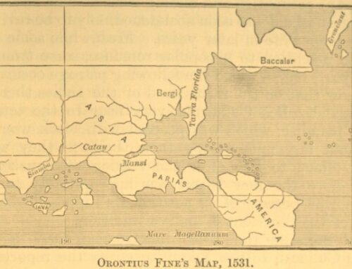
According to Orontinus Fine’s 1531 Map of Asia as North Americas, Parias is located in the Yucatan Territory of Central American. The name Parias is synonymous with Al-Andalusia. “In medieval Spain, parias (from medieval Latin pariāre, “to make equal [an account]”, i.e. pay)[1] were a form of tribute paid by the taifas of al-Andalus to the Christian kingdoms of the north.[2] Parias dominated relations between the Islamic and the Christian states in the years following the disintegration of the Caliphate of Córdoba (1031) until the reunification of Islamic Spain under the Almoravid dynasty (beginning in 1086).” [End quote from Wikipedia: https://rb.gy/ydaclh.].
Parias means a tax, or a tribute paid by the defeated Moors of Al-Andalus to the Christian Kingdoms of the North, so that the Moors could keep their lands. This means that Parias was once Moorish land that was known as Al-Andalus. Al-Andalus is also synonymous which Granada. My previous blog post shared in this post, entitled, “Granada Land is the Promised Land,” proves that greater Granada land (Al-Andalus or Promised land) was in the Americas and it was a huge territory of land that covered most of the Americas.
Additionally, we have Andalusia Alabama, Andalusia Florida, Andalusia Square in Pensacola, Florida. We must also consider Granada, Florida and Iberia, Louisiana. Here is a previous blog post proving that the Iberian Peninsula, Hispaniola, the Garden of Eden, the Fountain of Youth, the Garden of the Hesperides, and the Rock of Gibraltar was in the Americas: https://www.americaistheoldworld.com/gibraltar-of-the-west/.
The Americas was the Original Africa:
Since ancient Punt is allegedly located in the Horn of Africa, here is a previous post entitled, “ Imperial Rome and Italy Superior,” proving that the original Africa was in South America and La floridas was an extension of North Africa: https://www.americaistheoldworld.com/imperial-rome-and-italy-superior/.
According to the blog link shared above, Saint Augustine, Florida was named after a North African Roman Consul that was a Berber (Moor). Saint Augustine, Florida is covered with Moorish Architecture and Moorish city place names that are associated with Al-Andalusia, Spain
Here is further proof that the original Africa was in South America since ancient Ghana and the first Gold Coast and Slave Coast was there. Here is my previous blog post entitled, “Ancient Ghana is Guyana”: https://www.americaistheoldworld.com/ancient-ghana-is-guyana/.
Since the original Africa was in the Americas, the original Land of Punt was also in the Americas by default. According to scholars and theologians, Punt was in the Horn of Africa, so the Americas wins by default. This is especially true since the Americas has way more Punt and Ethiopian place names that cover larger territories of land. Africa has one Punt and one Ethiopia while the Americas has several of both place names.
America is the Land of the Gods, aka, Punt:
America is the Land of the Gods since we have already proven that the original and/or the superior Land of Punt (land of God) was in the Americas. This is especially true with places in the Americas that were named after the gods, like: Jupiter, Florida; Venus, Florida, Neptune Beach, Florida; Juno Beach, Florida; Athens (Athena), Georgia; Atlanta (Atlas), Georgia; the Valley of the God-Kings in the Grand Canyon; the Valley of the Gods in Utah; the Garden of the Gods in Colorado/ El Dorado; the Garden of the Gods in Illinois; and the Apukunaq Tianan, or Abode of the Gods, in Cusco.
Yes, America is the Land of the Gods (the Land of Punt) since the Gods come from the Americas based upon the overwhelming evidence given above. Please donate to my Cashapp: $Amunhotep7. Thank you for your time and for your support. Peace and love.


Leave a Reply