


 Pass")
“Ancient Afghanistan was in Missouri,” is not intended to take away from any of the glory from the counterpart ancient Afghanistan in Asia Minor, but only to prove that America is the True Old World.
I must give a shoutout to Khandrop 432 the drop radio, even though he hates Moors and Islam, because he made an informative video proving that ancient Afghanistan was in Missouri. The name of the video is called, “Prestor John #70| Afghan, son of Jeremiah, Grandson of Saul the son of Kish Rashid.” Before you watch this video, I must correct Khandrop, because the brother misunderstood a passage from the book he was reading from, “The Medieval Empire of the Israelites,” on page 323 at the 49:00-minute mark of the video; since the author never said that Islam was created in the 17th century. The author was referring to the assertion that, “The rulers of Afghanistan as being descendants of the ancient Israelites from the Tribe of Benjamin.” The author went on by saying, “that this assertion was expressed only in the 17th Century. This is, after the breakup of the empire and the birth of Islam.”
To clarify this point, the reason why the author said the above quote is because no one knew that King Afghana (the founder of ancient Afghanistan) was an Israelite, since it was a hidden fact that he was the son of Jeremiah and Grandson of King Saul, until an Arab historian published a book in the 1600’s about the history of Afghanistan. This is why the author said, “that this assertion was expressed only in the 17th Century [1600’s]. This is, after the breakup of the empire and the birth of Islam.” Yes, this assertion from the 17th Century clearly came after the breakup of the Israelite Empire and the birth of Islam, since Islam was created in the 7th Century, which is well-established by historians. You have to excuse Khandrop, because his hate for Moors runs deep, however, he is a good scholar which is why I used his video. Now, that we have clarified the video let’s move on to proving that Ancient Afghanistan was in Missouri.
THE KHYBER PASS IN PAKISTAN ON THE BORDER WITH ANCIENT AFGHANISTAN:
According to academics, the Khyber Pass is in Pakistan on the border with ancient Afghanistan. “The Khyber Pass (خیبر درہ) is a mountain pass in the Khyber Pakhtunkhwa province of Pakistan, on the border with Afghanistan (Nangarhar Province). It connects the town of Landi Kotal to the Valley of Peshawar at Jamrud by traversing part of the Spin Ghar mountains. Since it was part of the ancient Silk Road, it has been a vital trade route between Central Asia and the Indian subcontinent and a strategic military choke point for various states that controlled it.”: https://en.wikipedia.org/wiki/Khyber_Pass.
By reading the above quote we know that the Khyber Pass is in Pakistan on the border with ancient Afghanistan, so we must first learn where is Pakistan and Afghanistan to get an ideal of where the Kyber Pass is. Let’s start with Pakistan since we have a Pakistan, Arkansas in America. Pakistan, Arkansas, just like its counterpart Pakistan in South Asia has a Mountain pass. The Ozark Mountains run not only through Arkansas but also in parts of Missouri, Oklahoma, and Kansas.
Plus, the Ozark Mountains are nearest to Missouri. I put emphasis on Missouri since Missouri has a city called Cabool, Missouri. Cabool/Kabul is the Capitol of ancient Afghanistan. This is a significant fact since the Khyber Pass is a mountain pass in Pakistan that is on the border with ancient Afghanistan.
THE INDUS VALLEY CIVILIZATION AND THE HINDU CUSH MOUNTAINS IN THE AMERICAS:
The Hindu Cush Mountains is an 800-kilometre-long (500 mi) mountain range in Central and South Asia to the west of the Himalayas. It stretches from central and western Afghanistan[2][3] into northwestern Pakistan and far southeastern Tajikistan. The range forms the western section of the Hindu Kush Himalayan Region (HKH);[4][5][6] to the north, near its northeastern end, the Hindu Kush buttresses the Pamir Mountains near the point where the borders of China, Pakistan and Afghanistan meet, after which it runs southwest through Pakistan and into Afghanistan near their border.[2] The eastern end of the Hindu Kush in the north merges with the Karakoram Range.[7][8] Towards its southern end, it connects with the Spin Ghar Range near the Kabul River.[9][10] It divides the valley of the Amu Darya (the ancient Oxus) to the north from the Indus River valley to the south. The range has numerous high snow-capped peaks, with the highest point being Tirich Mir or Terichmir at 7,708 meters (25,289 ft) in the Chitral District of Khyber Pakhtunkhwa, Pakistan.
The Hindu Kush range region was a historically significant center of Buddhism, with sites such as the Bamiyan Buddhas.[11][12] The range and communities settled in it hosted ancient monasteries, important trade networks and travelers between Central Asia and South Asia.[13][14] While most of the region has had a Muslim majority for several centuries now.
Arkansas has three Mountain ranges: the Ouachita (Washitaw), the Ozarks, and the Boston Mountains. Together these mountains fit the description of the Hindu Cush Mountains, since these Mountain ranges combined are over 500 miles in total length. Likewise, the Hindu Cush Mountains are 500 miles long in length. The Mountain ranges in Arkansas connect several states: Arkansas (Pakistan) Missouri (Afghanistan), Oklahoma, and Kansas. Likewise, the Hindu Cush mountains buttresses the Pamir Mountains near the point where the borders of China, Pakistan and Afghanistan meet, after which it runs southwest through Pakistan and into Afghanistan near their border.[2]
The Indus Valley Civilization[1] (IVC), also known Indus civilization, was a Bronze Age civilization in the northwestern regions of South Asia, lasting from 3300 BCE to 1300 BCE, and in its mature form from 2600 BCE to 1900 BCE.[2][a] Together with ancient Egypt and Mesopotamia, it was one of three early civilizations of the Near East and South Asia, and of the three, the most widespread. Its sites spanned an area from northeast Afghanistan and much of Pakistan to western and northwestern India.[3][b] The civilization flourished both in the alluvial plain of the Indus River, which flows through the length of Pakistan, and along a system of perennial monsoon-fed rivers that once coursed in the vicinity of the Ghaggar-Hakra, a seasonal river in northwest India and eastern Pakistan.[2][4]
The cities of the ancient Indus were noted for their urban planning, baked brick houses, elaborate drainage systems, water supply systems, clusters of large non-residential buildings, and techniques of handicraft and metallurgy.[c] Mohenjo-daro and Harappa grew to contain between 30,000 and 60,000 individuals,[6] and the civilization may have contained between one and five million individuals during its florescence.[7]
The Hindu Cush Mountains are famous for its Indus Valley Civilization that thrived due to the Indus River which ties into the Ganges River (see map of Indus Valley Civilization). Likewise, Arkansas has an Arkansas valley (Indus Valley) that thrives due to the Arkansas river (Indus River), the second longest tributary of the Mississippi River (the Nile) that flows into the Colorado river (Ganges River).
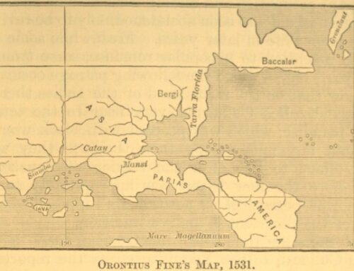
Yes, the Colorado River used to be the Ganges River and I got a 1531 map of Asia by Orontinus Fine that designates North Americas as Asia and Catay (China). Over to the far left of the said map you will see the Ganges River. Based upon all of the evidence, the Arkansas Valley is the Indus Valley Civilization, the Arkansas River is the Indus River, the Colorado river is the Ganges River, and the three Mountain ranges of Arkansas are the Hindu Cush Mountains.
THE THREE PYRAMIDS OF THE OUACHITA MOUNTAINS:
The Arkansas River, being the second longest tributary of the Mississippi River (Nile River), is 1,469 miles long and is the sixth longest river in the United States, so yes this is a great river. The word “Nile” is a Greek word that means great river. The Arkansas River (the Indus & Nile River) runs through the Ouachita Mountains and the Arkansas Valley, and it is a river source of life (water) for both areas. All ancient and modern civilizations are based around large bodies of fresh water since life needs water to survive.
The interesting thing about the Ouachita Mountains and the Arkansas Valley (Indus Valley) area is that there was once a Nahari, Arkansas near this area. Naharina means, “Nile Land,” and you can locate Nahari on this 1741 Map of Carolana and the River Meschacebe & c: https://collections.leventhalmap.org/search/commonwealth:3f462v04v. Please click on the map to zoom in when you open the link to see Nahari and a huge portion of America listed as Carolana.
Yes, Carolana (Carolina) was once a vast Country, and it is part of Grand or Superior Turkey, since we know that North and South Carolina (Kara-lana) in America was ancient Turkey: https://www.americaistheoldworld.com/ancient-turkey-was-in-south-Carolina/. Carolana is Turkish and it means “Land of the Blacks”, aka, Ethiopia or Tameri (Lower). For example, Caro/Kara in Turkish, means “Black,” while Lana is Turkish and Latin for “Land.”
In this post is a 1657 map of La floridas that is identical to the 1741 map of Carolana that was shared above, since this map of La floridas is identical in size, shape, and location, so we are dealing with the same land and territory here. The interesting thing about the map of La floridas is that it has “Tamerikaans” (Tameri-Khans), written above the plaque of Florida. Tameri is an old name for ancient Egypt, and it means land of Mary (Mauritania) or the land of the Maurs. La Florida or Carolana (Lower Ethiopia/Egypt) used to be part of the Washitaw Proper, aka, Louisiana county, according to old maps from the 1700’s, so… yes…, this landmass was indeed, Tameri, “the Maurs land or the land of the Maurs.”
Look how big La Florida used to be and it covered several states reaching all the way over into Texas and reached all the way up into Canada. Texas and several other states used to be part of Mexico. Mexico was also Southern Arabia. Mexico means “In the Center of the Moon.” Most Moorish Islamic Flags feature the 5-pointed star in the Center of the crescent moon. The 5-pointed Star of Mary/Venus (love) is Mayan, and it comes from Mexico: https://rb.gy/byyilq.
According to the book, “The Journey of Coronado,” “may it be possible to understand in what direction Florida lies and in what direction Greater India; and this land of New Spain is part of the mainland with Peru, and with Greater India or China as well, there not being any strait between to separate them.”
Now that we know that a substantial portion of America was Tameri (old name for Ancient Egypt), lets refer back to the Ouachita (Washitaw/Wichita) Mountains since there is an Ouachita National Forest, Hot Springs National Park, and a Hot springs Arkansas, a city in the Ouachita Mountains. When you think of Hot Springs and parks you think of a fun paradise, which suggests that they are hiding a lost paradise with all of the vegetation growth and trees in these National and State Parks in this area. This is certainly the case since you got three ancient Egyptian pyramids near the Pinnacle Mountain. In fact, the pinnacle mountain is one of those three pyramids (see post images).
As you can see, these pyramids are covered with vegetation growth, and you can barely determine that they are pyramids. However, their location near Nahari (Nile land), along the Arkansas River (the Nile) and the triangular shape of these three mountains (pyramids), and their alignment with the Orion Constellation is overwhelming evidence suggesting that these three mountains are ancient Egyptian pyramids. The National and State Parks in this area were purposely put in place to hide these pyramids and the ancient Egyptian civilizations that were built around them.
THE GRAND QUIVIRA PASS WAS THE GRAND CANYON:
Previously, I did a blog post entitled, “Ancient China the Land of the Orient,” that proves that the Americas is the Orient (the East), China, and India Superior (Asia Major). This post also proves that the Silk Road was in the Americas: https://www.americaistheoldworld.com/ancient-china-the-land-of-the-orient/.
With all of this evidence the Khyber Pass must be somewhere in North America, which was formerly Asia Major/India Superior. But where? Do we have a Khyber in America? Yes, we do! For example, with the use of etymology we can learn that Khyber is the same as Kheeber (Eber), Kheevira, and Quivira since the “KH” has the same meaning and pronunciation of the “Q,” Kheevira became Quivira. America was Grand Quivira (Quivirae regnum), so we are also dealing with a Grand Quivira Pass.
Dr. Gene D. Matlock agrees with me, and he authored a book entitled, “Khyber (Kheeber) pass to Gran Quivira (Kheevira), NM and Baboquivari, AZ: When India Ruled the World.” Just by reading the title of the book, you realize that Dr. Matlock came to the same conclusion that Khyber is etymologically the same as Quivira. Additionally, Dr. Matlock gives us a strong hint as to the location of the Gran Quivira pass with his book title, even though he didn’t specifically specify that the Grand Canyon in Arizona was the Grand Kyber pass.
Let’s look at Dr. Matlock’s book title again, “Khyber (Kheeber) pass to Gran Quivira (Kheevira), NM and Baboquivari, AZ.” Based upon the book title, the only Grand Pass (passage) that I can think of that is between New Mexico and Arizona is the Grand Canyon (Grand Quivira) pass, which is short for passageway. I will further prove this point later because I will demonstrate just how grand the passageway was through the Grand Canyon.
THE ANCIENT EGYPTIAN VALLEY OF THE KINGS WAS IN THE GRAND CANYON:
The Grand Canyon (Grand Quivira) Pass, which is an ancient structure that aligns with the Orion constellation (See post images). It was the custom of the ancient Egyptians to align their pyramids to the Orion constellation, so we are dealing with a period of at least over 5,000 years ago, that is, if we use the academic model, since this is the time-period when the step-pyramid of Pharoah Djoser (Joseph) was built in Egypt in Africa.
The interesting thing about the Grand Canyon is that it is rumored to be the ancient Valley of kings, according to Terry Carter, “Ancient Egyptians in the Grand Canyon Fighting Fake News”: https://www.youtube.com/watch?v=umGwA679b9Q&t=185s.
I agree with Terry Carter since there are ancient temples and pyramids in the Grand Canyon that are named after Egyptian Gods and Hindu Gods, plus ancient Egyptian Hieroglyphics have been found in the Grand Canyon, as well as giant Egyptian Mummies. In Oklahoma in the 1800’s, a stele of Pharaoh Akhenaten (Amenhotep IV, aka, Moses of the Bible) was found (See “Ice: The Ultimate Disaster,” by Richard Noone). In the book, “America BC,” there is an alabaster egg of a cartouche of King Tut found in Idaho. I did a blog post that proves that the Americas is Ancient Egypt, which supports the notion that the Grand Canyon was also the ancient Valley of the Kings: https://www.americaistheoldworld.com/ancient-egypt-was-in-the-americas/.
The above evidence was found in 1905, in the Grand Canyon by two Smithsonian-funded archaeologists, Prof. S. A. Jordan and G.E. Kinkaid, according to the April 5, 1909, edition of the Arizona Gazette. Of course, the Smithsonian covered this evidence up, because it goes against the false narrative of the Americas being a new and uncivilized world that was first discovered by Christopher Columbus in 1492. This evidence would have rewritten history, so the Smithsonian Institute had to cover up this find.
Additionally, the Grand Canyon (Grand Quivira) pass has two giant Pharoah heads on its grand passage, one of the heads looks male while the other looks female, and an Egyptian Sphinx (see post images).
THE GRAND CANYON PASSAGEWAY (PASS) WAS A CITY OF GOLD AND A MAJOR TRADING HUD THAT WAS PART OF THE ANCIENT SILK ROAD:
The interesting thing about Quivira is that it is one of those mythical seven golden cites, which is also shown on the maps I shared below: https://en.wikipedia.org/wiki/Seven_Cities_of_Gold. “It is in the Mythical that we have the truth.” ~ Greek proverb. My advice friends is to look for the truth in every myth, because our history was so great that it was too much to hide; therefore, all of our great history that they couldn’t hide from us they just told us that it was mythical so that we would not attach ourselves to the greatness. Below are all of the maps that I gave as evidence. Please zoom in and see it for yourself.
1660 map of America. Notice that this map shows you California as an Island, Cibola, Granada, Anian, and Quivira. You may have to click on the link I gave from the Stanford University library, so that you can zoom in to see it better: https://exhibits.stanford.edu/california-as-an-island/catalog/vc916yx0598.
Quivirae regnum, cum aliis versus Boream. Novae Gvineae Forma & Situs. From the atlas: Speculum orbis terrӕ. Antverpea, 1593-1613. P. 12. Maps of part of North America (Quivira) and New Guinea from the world atlas Gerard de Jode «Mirror of the World». Antwerp, 1593-1613. P.12. The map of Quivira contains a text in which residents of the area are compared with the Tartars – a reference to the theory that North America was part of Asia: https://www.pinterest.com/pin/382383824609960596/. Notice the Dragon and the lion on this map too.
1650, Barry Lawrence Ruderman Map of America from the Stanford Library: https://searchworks.stanford.edu/view/vr898bw7334. Notice that this map shows you Cibola, Granada, and Quivira. You may have to click on the link I gave from the Stanford University library, so that you can zoom in to see it better.
Based upon the maps, we know for sure that Grand Quivira was in America, how does the Grand Canyon fit the description of being a golden city? Well, according to an article from the New York Times, June 19, 1912, billions of dollars’ worth of gold was found in the banks for the Colorado Canyon (See N.Y. Times newspaper article). The Colorado Canyon is also the Grand Canyon River basin or the banks along the canyon, since the Colorado river (Ganges River) flows through the Grand Canyon passageway or Pass.
How do you explain this much gold found in the riverbanks along the Grand Canyon? This evidence suggests that the Grand Canyon was once plated in gold (a golden city), hence the name Grand Quivira Pass, because this was one Grand passageway during the old-world.
What happened to the gold and the building structures along the Grand Canyon? Well, there was an ancient nuclear war or there was a major heat event that melted the gold off the structures and melted those buildings along the Canyon. This explains why a lot of the mountains and rock structures in the Grand Canyon are in ruins and look like buildings that melted. I am not alone in my theory as to what happened to the Grand Quivira Pass, because there are Facebook groups you can join about melted buildings and its YouTube channels that give out a ton of information on this melted building theory. One of those channels is called, “When the buildings cried 4.0”: https://www.youtube.com/watch?v=vCdInluv3R0.
Based upon the above evidence, the Grand Canyon was not only the Valley of the Kings, but also the Grand Quivira Pass that was a major trade route along the ancient Silk Road that connected India Superior (America) with Central Asia (Central America). This evidence also proves that the Silk Road was in the Americas since the Khyber Pass played a pivotal part as a major trade route that connected India with Central Asia.
CABOOL MISSIOURI WAS THE CAPITAL OF ANCIENT AFGHANISTAN:
Cabool Missouri located in Texas County, Missouri was allegedly named after Kabul Afghanistan, because this area of southern Texas County looked like the region of Kabul, Afghanistan. I believe, and according to old legend that this area was named after an Indian Chief/ Sheik named Kabul: https://en.wikipedia.org/wiki/Cabool,_Missouri (Read the section entitled, “Etymology.”).
Cabool, etymologically, is the same as Kabul since the vowels are interchangeable with most ancient languages. Even when you study the etymology of the Kabul in Afghanistan you will learn that Cabool and Kabul are etymologically one and the same word. (“Kabul (/ˈkɑːbuːl/,[19] /ˈkɑːbəl/; Pashto: کابل Kâbəl, IPA: [kɑˈbəl]; Dari: کابل Kābol, IPA: [kɒːˈbol])[20] is also spelled as Cabool, Cabol, Kabol, or Cabul.” [End quote from the Toponymy and Etymology section of Kabul Afghanistan: https://en.wikipedia.org/wiki/Kabul. ].
Which Kabul (Cabool) is older since we are discussing the capital and largest city in ancient Afghanistan? Well, Cabool Missouri is located in the Orient (the East) and the true old world (the Americas), so it is the oldest in my book, which means that Kabul Afghanistan was patterned after the American Cabool Missouri. Plus, this also means that Cabool Missouri is the ancient Afghanistan, since it is the oldest.
IS THE CAPITAL OF ANCIENT AFGHANISTAN, KABUL, IN THE BIBLE?
Kabul is the Biblical Cabul mentioned by Joshua. Fragments of pottery from the Persian period have been found in Kabul, as well as excavated burial chambers, used from the 1st to the 4th centuries. In Roman times, Josephus called the town “Chabolo” and camped there.
THERE IS AN AFGHAN MARKET IN ST. LOUIS MISSOURI:
In this post is an image of the Afghan Market in St. Louis Missouri that consists of Sameem Afghan Restaurant & Catering, Afghan Chopan Kabab STL, and the Kabul Express STL. Afghans live in Afghanistan; therefore, Afghan is short for Afghanistan, which is their Nationality because people name themselves after landmasses or the territory that they live in. To have an Afghan Market in Missouri is alluding to the fact that Missouri was once Ancient Afghanistan. The proof is in the culture.
Ancient Afghanistan has a long history of domination by foreign conquerors and strife among internally warring factions. At the gateway between Asia and Europe, this land was conquered by Darius I of Babylonia circa 500 B.C., and Alexander the Great of Macedonia in 329 B.C., among others.
ANCIENT AFGHANISTAN WAS SETTLED AT LEAST 50,000 YEARS AGO:
Early cities such as Mundigak and Balkh sprang up around 5,000 years ago; they were affiliated with the Aryan culture of India. Around 700 BCE, the Median Empire expanded its rule to Afghanistan. The Medes were an Iranian people, rivals of the Persians.
What was Ancient Afghanistan called in the Bible?
What was ancient Afghanistan known as in biblical times? Rabbi Saadia Gaon in the 9th century and Moshe ben Ezra (Eber) in the 11th century mention Afghanistan – then known as Khorasan – as the home of the Ten Tribes.


[…] Alexander the Great is significant in history since he helped to shape the future of the Silk Road and he was King of Egypt, Persia, and etc: https://depts.washington.edu/silkroad/exhibit/macedonians/essay.html. Alexander the great is from America since Afghanistan, Tameri (old Egypt), and the Silk Road is in the Americas: https://www.americaistheoldworld.com/ancient-afghanistan-was-in-missouri/. […]
[…] Alexander the Great is significant in history since he helped to shape the future of the Silk Road and he was King of Egypt, Persia, and etc: https://depts.washington.edu/silkroad/exhibit/macedonians/essay.html. Alexander the great is from America since Afghanistan, Tameri (old Egypt), and the Silk Road is in the Americas: https://www.americaistheoldworld.com/ancient-afghanistan-was-in-missouri/. […]
[…] Home/American History, Ancient American History, Ancient Civilizations, Ancient History, Black History, Black Indians, Black Native Americans, Lost Civilizations, Lost History, Untold History/Ancient Turkey was in South Carolina Previous Next […]